
Coastal Zone
The coastal zone, broadly defined as near-coast waters and the adjacent land area, forms a dynamic interface of land and water of high ecological diversity and critical economic importance.
From: Climate Change Impacts and Adaptation: A Canadian Perspective
Physical
The zone includes the beach, estuaries, the adjacent land draining directly into the coastal waters, and the offshore waters, usually out to the edge of the continental shelf. The physical characteristics are described in Types of Coasts.
Political
- Many people live in the coastal zone. Overall 38% of the world's population lives within 100 km of the coast or estuaries, and 44% live within 150 km of the coast..
- The number of people living within 100 km
of the coast increased from roughly 2 billion in 1990 to 2.2 billion
in 1995—39 percent
of the world's population. From World Resource Institute, Earthtrends.
Thus, each year roughly 50 million more people move into the coastal zone worldwide. - The coastal zone is important because it is a source of fish and minerals.
- The coastal zone is an important political entity.
What are coastal waters, and who controls what is done on and below the coastal waters of any country? These are very old questions, and the nations of the world have agreed to some extent on some answers.
- Each coastal nation can claim jurisdiction over all activity in a narrow band of ocean close to shore, the territorial sea.
- Each coastal nation can also control economic activity in a wider band of water called the Exclusive Economic Zone.
Here we will briefly consider the international framework, the laws of the United States, and the laws of the State of Texas.
Territorial Seas
The extent of each coastal country's territorial sea is defined by the UN Convention on the Territorial Sea and the Contiguous Zone, 1958 (click on the link near the top of the page to download a 200-KByte pdf file with the text of the convention).The UN also has a very interesting web page that puts the convention into an historical context. The following articles are taken directly from the Convention (note State refers to a country).
- The sovereignty of a State extends, beyond its land territory and its internal waters, to a belt of sea adjacent to its coast, described as the territorial sea.
- The sovereignty of a coastal State extends to the air space over the territorial sea as well as to its bed and subsoil.
- Except where otherwise provided in these articles, the normal baseline for measuring the breadth of the territorial sea is the low-water line along the coast as marked on large-scale charts officially recognized by the coastal State.
- In localities where the coast line is deeply indented and cut into, or if there is a fringe of islands along the coast in its immediate vicinity, the method of straight baselines joining appropriate points may be employed in drawing the baseline from which the breadth of the territorial sea is measured.
- Subject to the provisions of these articles, ships of all States, whether coastal or not, shall enjoy the right of innocent passage through the territorial sea.
- The coastal State must not hamper innocent passage through the territorial sea.
- In a zone of the high seas contiguous to its territorial sea, the
coastal State may exercise the control necessary to:
- Prevent infringement of its customs, fiscal, immigration or sanitary regulations within its territory or territorial sea;
- Punish infringement of the above regulations committed within its territory or territorial sea.
- The
contiguous zone may not extend beyond twelve miles from
the baseline from which the breadth of the territorial sea is measured.
US Presidential Proclamation 5928 Claiming A 12 Nautical Mile Territorial Sea For The U.S.
On December 27,1988, U.S. President Ronald Reagan signed proclamation 5928, which claimed a 12 [nautical] mile territorial sea for the U.S. As established by the United Nations Convention on the Law of the Sea (UNCLOS), the territorial sea is a belt of ocean which is measured seaward from the baseline of the coastal nation and subject to its sovereignty. This sovereignty also extends to the airspace above and to the seabed and subsoil. It is exercised subject to UNCLOS and other rules of international law relating to innocent passage, transit passage, archipelagic sea lanes passage and protection of the marine environment.
From NOAA Coastal Services Center.
Exclusive Economic Zone
The exclusive economic zone is an area beyond and adjacent to the territorial sea, subject to the specific legal regime established in this Part, under which the rights and jurisdiction of the coastal State and the rights and freedoms of other States are governed by the relevant provisions of this Convention ... In the exclusive economic zone, the coastal State has ... sovereign rights for the purpose of exploring and exploiting, conserving and managing the natural resources, whether living or non-living, of the waters superjacent to the seabed and of the seabed and its subsoil, and with regard to other activities for the economic exploitation and exploration of the zone, such as the production of energy from the water, currents and winds ... The exclusive economic zone shall not extend beyond 200 nautical miles from the baselines from which the breadth of the territorial sea is measured.
From UN Convention on Law of the Sea
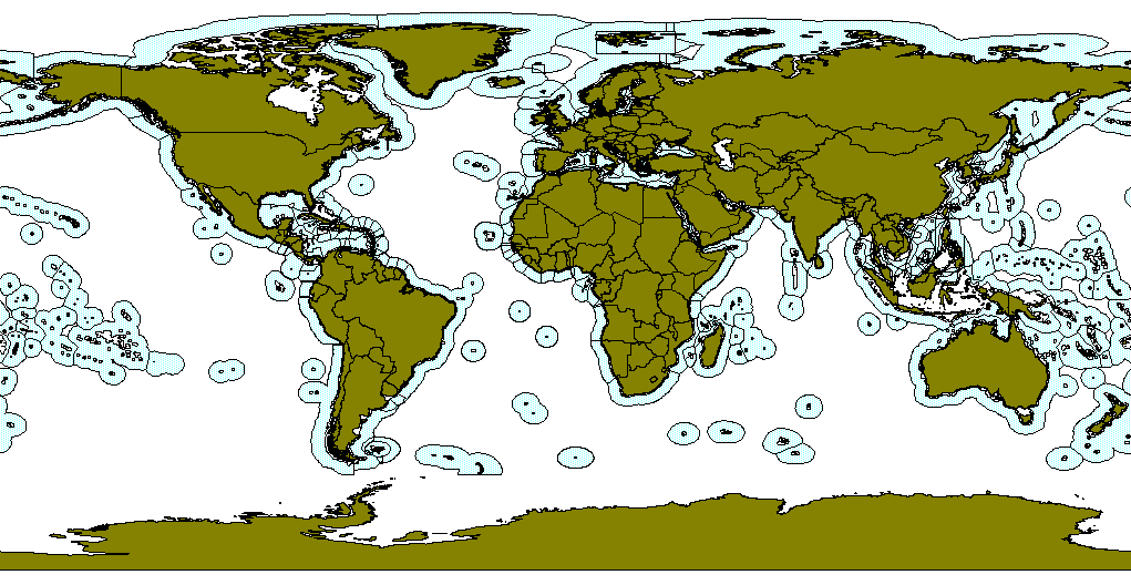
Boundaries of all Exclusive Economic Zones of the world. From CephBase Project of the University of Texas Medical Branch.
US Presidential Proclamation 5030 Creating The Exclusive Economic Zone
On March 10, 1983, U.S. President Ronald Reagan signed proclamation 5030, which established the U.S. Excusive Economic Zone (EEZ). This consists of those areas adjoining the territorial sea of the U.S., the Commonwealth of Puerto Rico, the commonwealth of the Northern Mariana Islands, and U.S. overseas territories and possessions. The EEZ extends up to 200 nautical miles (370 km) from the U.S. coastline. About 15 percent of this area lies on the geologic continental shelf and is shallower than 200 meters. Within its EEZ, the U.S. has sovereign rights over all living and non-living resources. Other nations may exercise freedom of vessel navigation and over flight within the U.S. EEZ (Source: Year of the Ocean Discussion Papers 1998; 2nd Ed. of Coastal and Ocean Law by Kalo et al. 1994)
From NOAA Coastal Services CenterBy the stroke of a pen and in an act that cost the United States nothing, America had in essence more than doubled in size. Debate continues over the exact size of the U.S. EEZ, but it is probably around 4 million square miles ... the territory around Hawaii alone is about 1 million square miles, or an area larger than Mexico. Historically, this action is comparable to the Louisiana Purchase of 1802. Yet because the seas draw so little attention, this proclamation was hardly reported in the news.
From Wilder, R. J. (1998). Listening to the Sea: The Politics of Improving Environmental Protection. Pittsburgh, University of Pittsburgh Press.
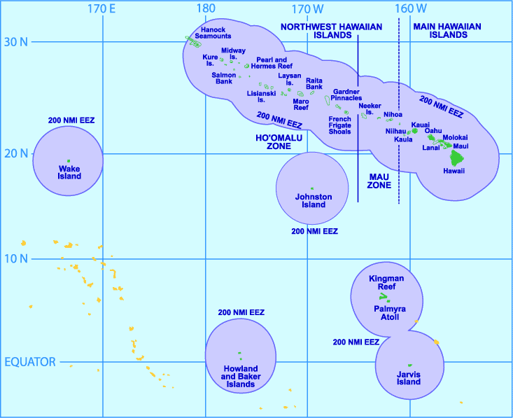
The largest Exclusive Economic Zone of the USA is in the Pacific. Most of the Northwest Hawaiian Islands is also a marine protected area.
From NOAA Pacific Islands Fisheries Science Center, Western Pacific Fisheries Information Network.
Coastal Zone Management in the US and Texas
The Federal Coastal Zone Management Act of 1972 provided incentives for coastal states to develop resource-management programs to regulate coastal resources.
The term "coastal zone" means the coastal waters (including the lands therein and thereunder) and the adjacent shorelands (including the waters therein and thereunder), strongly influenced by each other and in proximity to the shorelines of the several coastal states, and includes islands, transitional and intertidal areas, salt marshes, wetlands, and beaches ... The zone extends inland from the shorelines only to the extent necessary to control shorelands, the uses of which have a direct and significant impact on the coastal waters, and to control those geographical areas which are likely to be affected by or vulnerable to sea level rise.
The term "coastal waters" means ... those waters, adjacent to the shorelines, which contain a measurable quantity or percentage of sea water, including, but not limited to, sounds, bays, lagoons, bayous, ponds, and estuaries.
From Coastal Zone Management Act of 1972
The Marine Protection, Research, and sanctuaries Act of 1972 regulated the dumping of wastes into ocean waters, and it authorized the Secretary of Commerce to designate national marine sanctuaries for the "purpose of preserving or restoring areas for their conservation, recreational, ecological, or esthetic values." Originally, the sanctuaries had multiple uses, including fishing and resource use. Lately, NOAA has started to create zones within the sanctuaries where marine life is fully protected, although fishing is still allowed in most areas.
A. Seaward Boundaries
Section 304(1) of the Coastal Zone Management Act defines the seaward extent of a state's coastal zone as "to the outer limit of state title and ownership under the Submerged Lands Act (43 U.S.C. 1301 et. seq.)...." Under the Submerged Lands Act, Florida's title and ownership extends three miles into the Atlantic Ocean and, in accordance with United States vs. Louisiana, et. al., 364 U.S. 502 (1960), three marine leagues (approximately nine miles) into the Gulf of Mexico. Texas' title and ownership extends nine nautical miles. NOAA
but in no event shall the term "boundaries" or the term "lands beneath navigable waters" be interpreted as extending from the coast line more than three geographical miles into the Atlantic Ocean or the Pacific Ocean, or more than three marine leagues into the Gulf of Mexico, except that any boundary between a State and the United States under this Act [43 USC § § 1301-1315] which has been or is hereafter fixed by coordinates under a final decree of the United States Supreme Court shall remain immobilized at the coordinates provided under such decree and shall not be ambulatory;
From Section 1301—Definitions Submerged Lands Act.
B. Tidal Datums
The seaward extent of the various political divisions is from a line on the beach determined by the height of the tides, called the tidal datum. Mean Higher High Water (MHHW), Mean High Water (MHW), Mean Low Water (MLW), and Mean Lower Low Water (MLLW) are examples of tidal datums (i.e., vertical datums defined by a phase of the tide). In the U.S., the MLLW is the baseline from which more seaward boundaries are measured.
High and low tides used to define tidal datums. A tidal day is the time interval between two successive passes of moon past a place on earth, approximately 24.84 solar hours (24 hours and 50 minutes). It is also called a lunar day.
From NOAA Special Publication NOS CO-OPS 1: TIDAL DATUMS AND THEIR APPLICATIONS (2000).
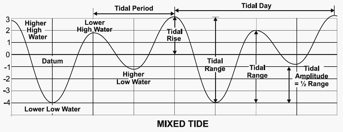
High Water: Maximum height
reached by a rising tide.
Mean High Water: The average of all the
high-water heights observed over the National Tidal Datum Epoch.
Higher High Water: The highest of the
high waters (or single high water) of any specified tidal day.
Mean Higher High Water: The average of
the higher high water height of each tidal day observed over the National
Tidal Datum Epoch.
Low Water: The minimum height reached
by a falling tide.
Mean Low Water: The average of all the
low water heights observed over the National Tidal Datum Epoch.
Lower Low Water: The lowest of the low
waters (or single low water) of any specified tidal day.
Mean Lower Low Water: The average of
the lower low water height of each tidal day observed over the National
Tidal Datum Epoch.
National Tidal Data Epoch: The specific
l9-year period adopted by the National Ocean Service as the official
time segment over
which tide observations are taken and reduced to obtain mean values for
tidal datums. The present epoch is is 1983 through 2001.
Because sea level is changing, rising along most coasts, dropping along Alaskan coasts, the tidal datum is recalculated every 20–25 years.
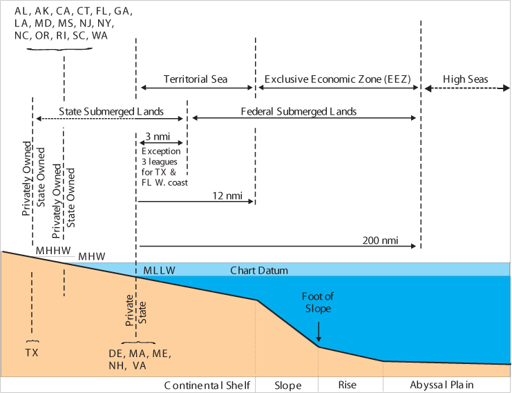
Simplified summary of US political boundaries within the coastal zone.
From: Federal Geographic Data Committee's Marine Boundary Working Group, Shoreline Boundaries Diagram.
C. Texas' Boundary
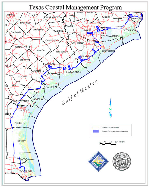
By 1975 the Texas Coastal Management Program had defined the Texas coastal zone as "southwest along the coast from the Sabine to the Rio Grande, seaward into the Gulf of Mexico for a distance of 10.35 miles (9 nautical miles, which was originally 3 leagues under Spanish law), and inland to include 36 counties." (Handbook of Texas) This zone is composed of eight geographic areas extending from the inner continental shelf to about forty miles inland. It includes all estuaries and tidally influenced streams and bounding wetlands.
Texas regulates fishing out to 9 nautical miles, and the federal government, through the Gulf of Mexico Fishery Management Council regulates fishing from 9 to 200 nautical miles from the coast.
Texas Coastal Management Zone as defined by the Texas legislature.
From Texas Coastal Coordination CouncilThe total coastal zone of Texas comprises an area of more than 33,000 square miles. The coastal counties have one-third of the state's population, one-third of its economic activity, 40 percent of the national petrochemical industry, 25 percent of the national petroleum-refining capacity, and three of the ten largest seaports; yet they make up only about one-tenth of the total land area of the state. The zone is richly endowed with natural resources. Its mineral production, largely of oil and gas, has a value of nearly $1 billion a year. Another $156 million comes from commercial fisheries. The fertile soils along the coast produce agricultural products valued at $500 million a year. The beaches and waters attract about three million tourists who spend nearly $1.6 billion per year.
From Handbook of Texas
Revised on: 27 May, 2017