
Earthquakes
The type of earthquake determines the potential for generating a tsunami. Earthquakes below subduction zones can have large vertical movement (reverse fault) that generates tsunamis. This animation from the BBC demonstrates what happens. Earthquakes on a strike-slip fault have mostly horizontal movement and tend not to generate tsunamis. For example, the magnitude 8.1 Macquerie Island earthquake near New Zealand at 1:59 AM local time on 23 December 2004 did not generate a tsunami. If you are not familiar with these types of fault motion, see these animations.
The size of a tsunami depends partly on the size of an earthquake, usually given as a Richter Scale magnitude.


Charles
Richter (left) and Breno
Gutenberg (right) invented
the Richter scale of earthquake magnitudes.
Richter's photo is from
the Nature,
Gutenberg's photo is from the National
Academy of Sciences.
An increase of one unit of magnitude (for example, from 8.1 to 9.1) represents a 10-fold increase in wave amplitude on a seismogram or approximately a 30-fold increase in the energy released.
Where are earthquakes common?
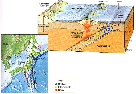
Earthquakes are not randomly distributed around the earth. They occur most frequently along plate boundaries. Very large, deep earthquakes occur at convergent boundaries where ocean plates move beneath other plates, at regions called subduction zones.
Location of earthquakes at subduction zones where an oceanic plate is subducted under another plate.
From Lecture Notes for Plate Tectonics Freshman Seminar class by Carolina Lithgow-Bertelloni at the University of Michigan and University College London.
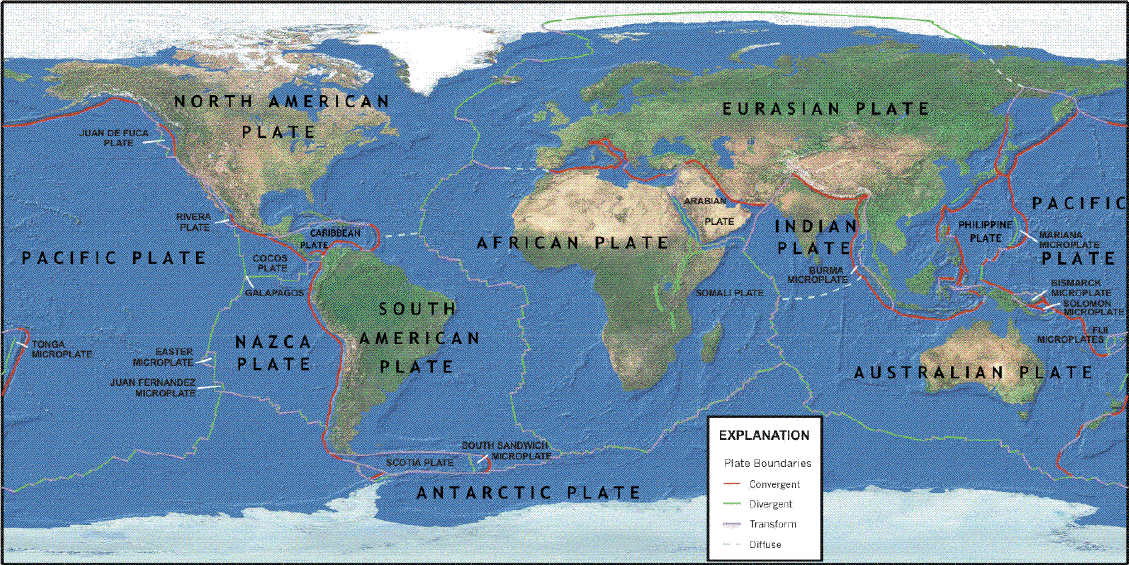
Location of plates and types of plate boundaries. Click on the image for a zoom. Red lines are location of subduction zones.
From United States Geological Survey, Plates of the Earth.
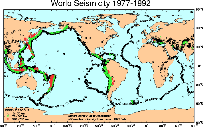
Map of earthquake locations and depths. Over 10,000 earthquakes with magnitude > 5.5 are plotted. Notice earthquakes are distributed along plate boundaries, and that their depth increases away from trenches, where oceanic plates move beneath other plates at subduction zones.
From Lamont-Doherty Cooperative Seismic Network.
The U.S. Advanced National Seismic System has maps fhowing distribution of earthquakes and cross-sectional plots of earthquake depth as a function of distance from trenches in three regions of the Pacific.
Location of largest earthquakes in the Pacific rim and Indonesia. Blue lines are locations oceanic plates move beneath other plates. Open circles are locations where the next very large earthquakes are expected to occur.
From McCaffrey (2007).
-f1.gif)
Large earthquakes, greater than magnitude 8.5 are rare. The Indian Ocean earthquake of 2004 was the third largest since 1900. A rough idea of frequency of occurrence of large earthquakes is given by the following table from the National Earthquake Information Center:
    Ms       Earthquakes
              per year
 ----------  -----------
 8.5 - 8.9       0.3
 8.0 - 8.4       1.1
 7.5 - 7.9       3.1
 7.0 - 7.4      15
 6.5 - 6.9      56
 6.0 - 6.4     210
This table is based on data for a recent 47 year
period. The rate of earthquake occurrence is
highly variable and some other 47 year period could give quite
different results.
Revised on: 27 May, 2017