
The Great Indian Ocean Tsunami of December 26,2004
The US Geologic Survey reported that at 7:58:53 AM local time on Sunday, December 26, 2004 a magnitude 9.0 earthquake ruptured the seafloor 250 km (155 miles) SSE of Banda Aceh, Sumatra, Indonesia, generating a tsunami that killed more than 280,000 people living near the coast in Sumatra, Thailand, Sri Lanka, India, and the east coast of Africa. This was the fourth largest earthquake in the world since 1900 and the largest since the 1964 Prince William Sound earthquake in Alaska.
What Happened?
Videos
The videos listed below show the tsunami coming ashore in several regions.They show very destructive waves causing many deaths. As you watch remember the many who drowned in the waves. I show them here to help you learn about tsunamis and how to protect yourself if you are ever so unfortunate as to be caught in a future tsunami.
The videos were downloaded from Waveofdestruction. The same videos, but with better descriptions, are at Asian Tsunami Videos. In watching the videos, pay particular attention to the shape of the wave as it comes ashore, its period, and how it causes damage and erosion. Where are these areas? How far are they from the earhquake? Does a tsunami have one or many waves? Is the first the largest? Do they come without warning?
- BBC Video of Tsunami hitting Banda Aceh.
- Video of tsunami at Banda Aceh.
- Video of tsunami at Patung Beach.
- Video of tsunami at Phuket.
- Video of tsunami at Kao Lak.
- Video of tsunami at Kao Lak 2.
- Video of tsunami at Phi-Phi Island.
- Video of tsunami at Kanyakumari, India.
- Video of tsunami at Thai Resort.
- Video of tsunami at Sri Lankan Resort.
First-Hand Accounts
- First hand account of Japanese tsunami.
- First hand account of Thailand tsunami.
- David Rucker and Sandi Thompson stood above the beach at a Ko Kho Khao Island resort in southern Thailand and stared for several minutes at the churning white line on the horizon, a tale from a survivor at Ko Kho Khao Island.
- More first hand accounts of Thailand tsunami.
- Chris and Lillian Chapman wrote an account for Nature (27 January 2005 issue, page 354).
Does knowledge of tsunamis help you survive one? Is the nature of the tsunami the same in each location? If not, how do they differ?
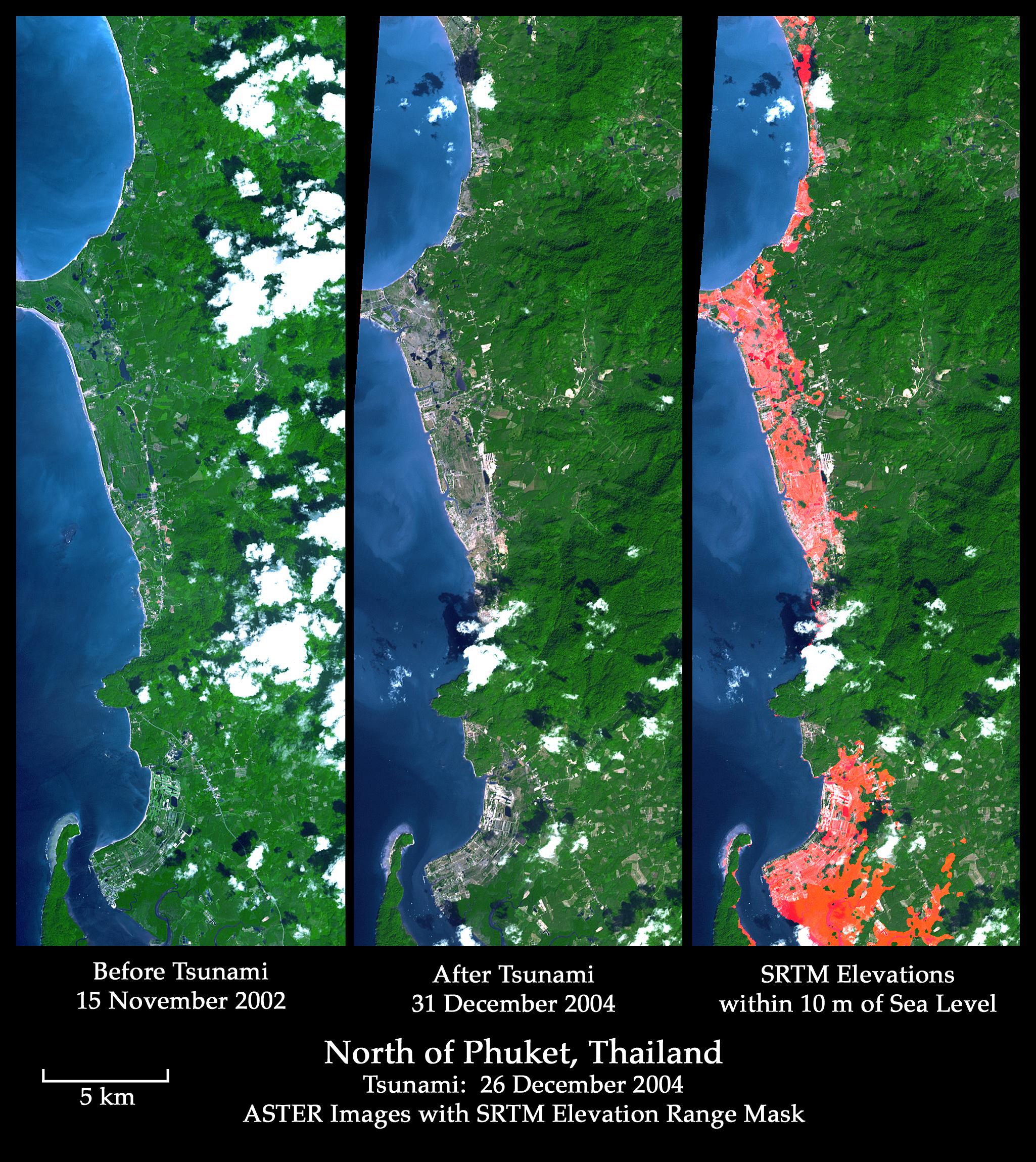
Satellite Images of the Destruction
- Japan.
- Aceh Province, Indonesia.
- Gleebruk, a small town located roughly 50 km (31 miles) from Banda Aceh, Indonesia.
- Little Andaman Island.
- Chennai, a harbor city on the southeastern Indian coast.
- North
of Phuket,
Thailand.
Click on image to zoom in.
What types of destruction and erosion do you see in the images? Does the extent of the damage depend on distance from the earthquake?
Revised on: 26 May, 2017