
Coastal Erosion
Coastal erosion is a problem for those who live near coasts and for marine organisms living along the coast in bays, estuaries, and shallow waters. We have seen that beaches change with the seasons, and that tsunamis and storm surges can erode coasts. How important is coastal erosion? Are we making it better or worse? What causes erosion? Can it be prevented? Or do we want to allow erosion as a natural process?
Many coastal areas are facing chronic long-term shoreline erosion problems. This is especially a problem along the low-lying barrier island systems of the Gulf and Atlantic coasts. Average erosion rates are 6 feet per year along the Gulf and 2 to 3 feet per year along the Atlantic. Some coastal areas may be accreting in the short term, but the general trend is in the direction of shoreline retreat.
Beatley, Brower, and Schwab (2002).
Coastal Erosion is Episodic and Sporadic
Download and read this Coastal Erosion Case Study and this study of Cape Cod before class.
The study has shown that the long term erosional rate for the bluffs in the area between the Pamet River and Beach Point averages less than 0.5 foot/year or less than 50 feet/century. Many residents and summer home owners develop a sense of security when property they have owned for decades has not eroded significantly. They are unprepared for sudden erosional events. However, when the bluffs do erode, they erode much more than 0.5 foot/year. The work of Uchupi and Giese suggests that the bluffs may erode 10-15 feet over a two to seven year period and then remain relatively stable for another 40-50 years.
Many other studies confirm this conclusion.
- Beach erosion is episodic. Most erosion occurs over a short period, sometimes in hours during a hurricane such as Katrina, sometimes during a season as in California during an El Niño event.
- Erosion is also sporadic. All areas are not eroded at the same rate
during a storm. Some areas have severe erosion during an event. Other
areas have mush less erosion.
- Some areas are constantly and rapidly eroding. The Mississippi delta region in Louisiana is a major example. Some areas erode meters per year.
- Other areas, such as the rocky west coast, erode at a rate of inches per year.
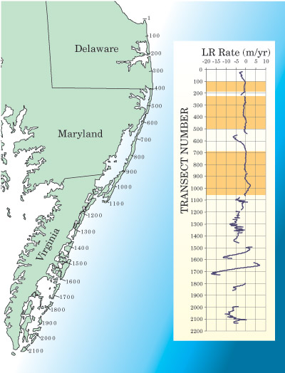
Erosion rates measured along the Delmarva coast. The location of the measurements shown in the inset is noted on the map on the left. Notice erosion rates are not uniform. Note also the large areas of deposition and erosion near locations 540 (Ocean City, see below), 1580, 1600, and 1700, all at channels between barrier islands. From Day (2004).
Examples of Episodic and Sporadic Coastal Erosion
- Erosion by Hurricane Rita
- Coastal damage at Gulfport by Hurricane Katrina. Notice in photos houses just inland were not as damaged as beach houses.
- Erosion in the Florida wetlands
- Erosion due to Hurricane Dennis.
- Erosion due to Hurricane Andrew
- Damage by Hurricane Jeanne
- Damage by Hurricane Ivan
- Teachers can find information at Coasts in Crisis
The Mississippi Delta is Rapidly Eroding
Deltas are normally slowly increasing in size due to sediment deposited by the river. The slow increase is due to a slight imbalance between sedimentation by the river, and sinking of the delta due to consolidation of deeper sediments. The balance has been upset by the construction of levees and dams along the Mississippi River leading to rapid erosion of the Mississippi River delta in Louisiana. It is the most rapidly eroding coast in the USA. Since 1900, about 4900 km2 of wetlands in coastal Louisiana have been lost at rates as high as 100 km2/year. The rate was 90 km2/year for the 1978-90 time period.
The rapid erosion is due to several factors, the first two being the most important:
- The construction of levees along the lower river that channel water
and sediments past New Orleans and out into the Gulf. This has stopped
sedimentation throughout the delta, and the delta is now rapidly sinking
below sea level. If the levees did not exist the river channel carrying
most of the river water would change position, and deposit sediments
throughout the delta. With levees, land subsidence of 4 to 4.3 feet
per century for the deltaic plain and 1.3 to 2 feet per century for
the chenier plains in western Louisiana is not balanced by sediment
from the river
– from LaCoast maintained by the US Geological Survey.
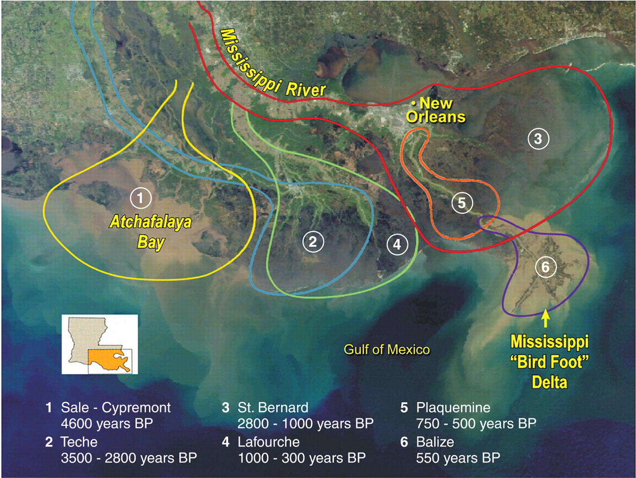
Location of Mississippi River channels discharging water into the Gulf of Mexico over the past 5000 years. Notice the location changes from time to time, keeping the all areas of the delta supplied with sediments. Today, two-thirds of the flow are through the Bird Foot Delta (6) and one third through the Atchafalaya (1). From Day et al (2007).
- The dredging of many canals to provide access to oil and gas wells.
The canals help salt water reach further inland, resulting in death
of trees and vegetation that stabilizes wetlands. Wind blowing along
the canals produces waves that erode the banks. And, storm surges produced
by storms travel along canals causing erosion further inland.
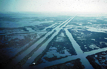
Canals dredged for navigation and hydrocarbon exploration in Louisiana. From USGS Fact Sheet on Louisiana Coastal Wetlands.
- Wetlands and coastal features are composed mostly of silts and clays that are easily eroded.
- Coastal features have little vertical relief.
Coastal Erosion is Aggravated by Man-Made Structures
To limit flooding, and to store water, governments build dams. To prevent loss of coastal land and buildings governments and property owners usually resort to building structures to hold back the sea and to prevent loss of sand. These structures do more harm than good over the long term.
- Dams store sediments keeping them from nourishing and replenishing
beaches. There are over 75,000 dams higher than six feet
in height in the USA, and 1,971 in Texas. With little sand flowing
to coastal areas, beaches are disappearing.
- Coastal structures designed to limit erosion cause increased erosion
in the long term.
- Groins and other structures designed to limit sand transport
along a beach, hold sand, and beaches down the beach are starved
of sand. Erosion is great along these beaches.
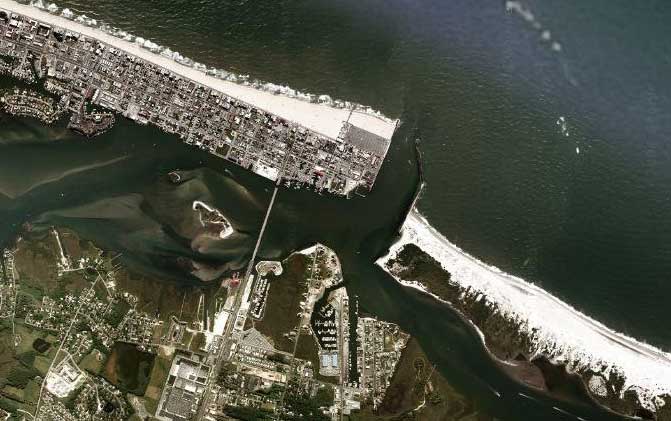
Groins installed at Ocean City have impeded sand flow from left to right in this image, causing beaches to the left of the navigation channel to grow, and beaches to the right to erode away. From Google Maps.
- Seawalls designed to impede erosion lead to greater erosion.
Sand in front of the wall gradually erodes away (that is why the
wall was built), and eventually waves reach the wall. When they
reflect off the wall, they create turbulence leading to faster
erosion, undercutting the wall.
- Navigation channels cut through barrier islands disturb sediment
transport along the island leading to erosion in some areas, and
beach growth in other areas.
- Destruction of coastal vegetation, including mangroves, leads to faster erosion rates.
- Groins and other structures designed to limit sand transport
along a beach, hold sand, and beaches down the beach are starved
of sand. Erosion is great along these beaches.
What to Do?
The problems seen in the film Portrait of a Coast are starkly highlighted at a coastal development on a Carolina coast, the Shell Island problem. Shell Island Resort is located on an offshore island, and an inlet at one end of the island is moving rapidly toward the resort. When it reaches the resort, the resort will be destroyed. The site outlines the problem, then provides background information on: What can be done? Should anything be done? Who should pay for any work?
Read why engineering solutions do not work in the long run. Beach structures such as seawalls and groins provide short-term solutions, and long-term problems.
Additional Source of Information
Day, J. W., Jr., D. F. Boesch, et al. (2007). Restoration of the
Mississippi Delta: Lessons from Hurricanes Katrina and Rita. Science 315
(5819): 1679-1684.
Hurricanes Katrina and Rita showed the vulnerability of coastal communities
and how human activities that caused deterioration of the Mississippi
Deltaic Plain (MDP) exacerbated this vulnerability. The MDP formed by
dynamic interactions between river and coast at various temporal and
spatial scales, and human activity has reduced these interactions at
all scales. Restoration efforts aim to re-establish this dynamic interaction,
with emphasis on reconnecting the river to the deltaic plain. Science
must guide MDP restoration, which will provide insights into delta restoration
elsewhere and generally into coasts facing climate change in times of
resource scarcity.
Day, C. (2004). Sea-Level rise exacerbates coastal
erosion. Physics Today 57 (2): 24–26.
Beatley, T., D. J. Brower, et al. (2002). An Introduction to Coastal Zone Management. Island Press.
Dean, C. (1999). Against the Tide: The Battle for
America's Beaches. New York, Columbia University Press.
This is a very useful book that documents beach processes and the difficulties
facing those who want to use technical solutions to save beaches.
Revised on: 28 May, 2017