
Storm Surges
Great Storms
Storms, especially hurricane and typhoons, kill many people, do great damage to coastal structures, and erode the coast. Great storms in the middle ages removed tens of kilometers of Germany's coasts in a few years. A storm surge in the North Sea in 1953 flooded a large area of the Netherlands and parts of eastern England, causing great damage and 2100 deaths. Hurricanes in the Gulf of Mexico move barrier islands, flood nearby land, and destroy coastal structures. "The greatest tropical system disaster this century occurred in Bangladesh in November 1970. Winds coupled with a storm surge killed between 300,000- 500,000 people." And the hurricane that struck Galveston Island on the evening and night of 8 September 1900 killed more than 6,000.
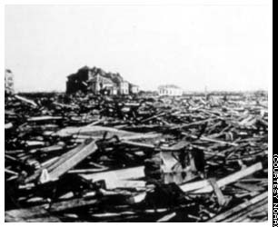
Left: Panorama of Galveston after hurricane
hit the city on 8 September 1900. Right: Another view.
From Texas State Archives and http://www.1900storm.com/.
The Rosenberg Library in Galveston has many more photographs online.
Many other hurricanes have caused severe damage to the coast of the United States.
Storm Surges
Storm surges are caused by hurricanes, typhones, and extra-tropical storms, The damage results from waves riding on a rise of sea level, the storm surge. Many processes influence the height of the surge.
- Wind speed. The force of the wind on the water is proportional to wind speed squared.
- Wide shallow continental shelf offshore.The surge is directly proportional to the width of the shallow water, and inversely proportional to the depth. Essentially, hurricane force winds blowing onshore across tens of kilometers of shallow water pile up water along coasts. The stronger the wind, the shallower the water, and the greater the extent of shallow water, the higher the pile of water. In some cases it can exceed 2-5 meters. In Galveston, Isaac Cline, the chief meteorologist, measured a rise of sea level greater than 16 feet above mean sea level.
- Tides. If the surge occurs at high tide, the tide adds to the height of the surge.
- Shape of the coast and winds at other areas along the coast. The surge can travel along the coast, causing high waters away from the strongest winds.
- Barometric pressure. Sea level rises one centimeter per millibar drop is air pressure. Strong storms can have 50 millibar drop in pressure, causing a 50 cm rise in water levels on top of levels due to wind and tides.
All these factors are included in numerical forecasts of storm surge height produced by meteorological agencies such as the U.S. National Oceanic and Atmospheric Administration NOAA.
The NOAA Storm Surge web page shows areas inundated by historic storms. The National Hurricane Center has maps showing potential inundation. Other maps are available online. NOAA has a web page that describes the different categories of storms according to the Saffir-Simpson Hurricane Scale.
To get a more graphic understanding of storm surges, look at these simulated storm surges for historic storms.
Long-Term Changes in Frequency of Surges
The frequency of hurricanes and other severe storms depends on oceanic conditions, especially sea-surface temperature. Temperature over large oceanic areas, such as the north Atlantic or Pacific, changes from decade to decade. The Atlantic Multidecadal Oscillation AMO and the Pacific Decadal Oscillation PDO are two examples of long-term changes in temperature.
Changes in the north Atlantic surface temperature is linked to changes in hurricane frequency. Warm temperautres are associated with many more hurricanes.
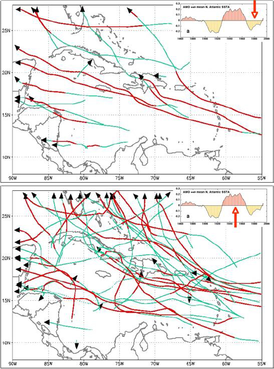
Paths of Atlantic hurricane during the two phases of the Atlantic Multidecadal Oscillation.
Top: Cold Phase. Bottom: Warm Phase.
From From Atlantic Multidecadal Oscillation web pages at the NOAA Atlantic Oceanographic and Meteorological Laboratory.
Mitigating Factors
Storm surges are reduced by:
- Offshore barrier islands and coral reef. Barrier islands are "shock absorbers" absorbing storm surges. The shallow water slows the surge of water, reducing its amplitude at the mainland shore. Water travels at a velocity of roughly square root (gH), where g = gravity, and H = depth of water. In shallow areas above reefs H is small, and velocity is small.
- Mangrove forests at the shore. The tangle of branches slows the flow of water.
- Forests just inland of the beach. Many areas have, of had, extensive
forests in the low flatlands just inshore of the
beach that slow the velocity of water and reduce the height of waves
and storm surge. Forests and mangrove areas also have many other uses:
They are nurseries for fish, shrimp, crabs, and other valuable marine
life; they provide wood and forest products; and they are a refuge
for wildlife.
In April 1991 a cyclone ravaged the Chittagong coastal belt [Bangladesh], located in the southern part of the country. But people of Mirsarai and Sitakunda, two coastal locations, suffered least casualties and property damage in the cyclone primarily due to protection provided by a one-or-two kilometre wide belt of plantations along the shore. This proved the effectiveness of coastal plantations as protection against cyclone and storm surges. From Natural Disasters, Forest and Environmental Security.
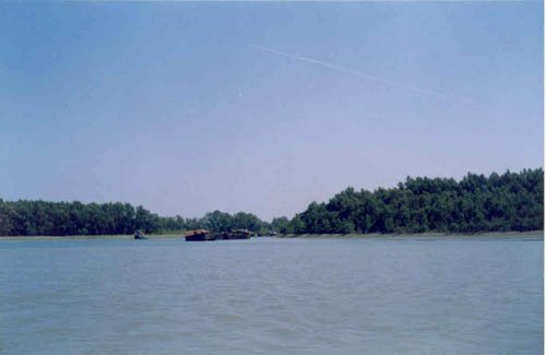
A view of Sundarban Mangrove forest of Bangladesh that has proven to be effective in reducing storm surges.
From: http://www.ramsar.org/wn/w.n.bangladesh_sundarbans.htm
- Lack of levees along rivers in coastal deltas. Flooding rivers deposit sediments in the lowlands of their their deltas, keeping the areas well above sea level.
Unfortunately, coastal development has removed many of these barriers.
- Tsunami damage in Thailand in 2004 was much worse onshore of areas where coral reefs had been mined for rock.
- Mangrove forests have been replaced by shrimp farms, and coastal forests have been replaced by houses, commercial buildings, streets, and highways.
- The extensive system of levees along the Mississippi River has prevented the flooding of delta areas, forcing the river to deposit sediments in shallow offshore areas. As a result, the lowlands of the delta gradually sank below sea level. New Orleans, originally above sea level in the 19th century, was up to seven meters below sea level by the beginning of the 21st century. Hurricane Katrina's storm surge in August 2005 breached the levees protecting the city, leading to disastrous flooding and loss of life.
- There is some evidence that the loss of coastal barriers made the hurricane Katrina storm surge worse, leading to the flooding of New Orleans in August 2005.
Extensive erosion of coastal lowlands of the Mississippi delta in August 2005 by the storm surge generated by hurricane Katrina.
Image from Wall Street Journal, 2 September 2005, page B1.
Further Reading
Isaac's Storm (1999) by Erik Larson, Crown Publishers, gives a thorough account of the Galveston hurricane of 1900, including first hand-accounts of those who survived a category 5 storm.
Revised on: 29 May, 2017